Title: An integrated animal tracking technology combining a GPS tracking system with a UAV
Tinghao Jin, Xingfeng Si, Juan Liu, Ping Ding
First published: 30 December 2022
Abstract
1. Global Position System (GPS) tags are widely used in animal tracking to address far-ranging ecological, behavioural and conservation-related questions. However, GPS tags with transmitting functions via Global System for Mobile communications (GSM) and long-lasting batteries are too cumbersome for animals with small body sizes. In addition, GSM is expensive with strict signal limitations in remote areas. Downloading locations from small GPS tags also requires animal recapture, which can result in large workloads. Combined, these problems limit the use of GPS tags in tracking small animals.
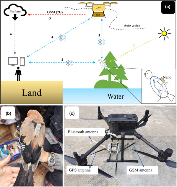
2. To overcome these challenges, we present an integrated technology to pinpoint animal locations, especially those of medium- and small-sized species. Our system consists of 3.7 g solar-powered GPS tags (Nano), whose sampling frequency can be changed flexibly, and a combination of a receiver and an unmanned aerial vehicle (UAV) to retrieve data. The UAV carries the receiver that can retrieve data from Nanos via Bluetooth. Data are uploaded to a platform via GSM by the receiver and then downloaded by users in real time. Users can also directly download data from tags or the receiver via Bluetooth.
3. We conducted stationary and field tests to assess the system's performance in Thousand Island Lake, China. Stationary tests were conducted at eight sites near the buildings, in open fields and on an island. Nanos can transmit data to the receiver within distances of 600–1000 m and at speeds of 6–72 records/s. The mean accuracy was 10.44–23.32 m and the fix success rates (FSRs) were larger than 97%. In field tests, we captured and attached Nanos on six Eurasian jays Garrulus glandarius. The FSRs were larger than 98%. Using the UAV reduced the time spent in field.
4. Our system is labour-saving and accurate in locating animals larger than 80 g as tested in a land-bridge island system. Bluetooth transmission assisted by the UAV can overcome signal limitations and landscape blocks, and has the potential to be applied in inaccessible landscapes. The large memory of Nanos also allows for the retrieval of data from migratory species with strong site fidelity on their returns.
Link: https://doi.org/10.1111/2041-210X.14055